

Description
The three components of the rapid risk assessment procedure are: 1) EFAS streamflow and flood forecasting; 2) event-based rapid flood mapping 3) impact assessment (see Figure 3). A full description is provided in Dottori et al. (2016).
1) Flood forecast. Every time a flood event is forecasted in EFAS, we identify for each river section the reference peak discharge over the full forecasting period, considering the median value from ECMWF ensemble forecasts. Then, the magnitude of peak discharge is compared with the local flood protection level, and river grid cells where the protection level is exceeded are considered in the following steps of the procedure.
2) Rapid flood mapping. For each EFAS river section identified in step 1, we delineate flood prone areas using a catalogue of flood hazard maps covering all the EFAS river network. The catalogue is based on simulations run with the 2D hydrodynamic model LISFLOOD-FP, fed with flood hydrographs derived from the EFAS climatology through a statistical analysis of extreme values for several reference return periods. More details are provided in Alfieri et al. (2014). Local flood maps for the river sections of interest are combined to derive the event-based hazard map based on forecasted flood magnitude (shown in the “Rapid flood mapping” layer).
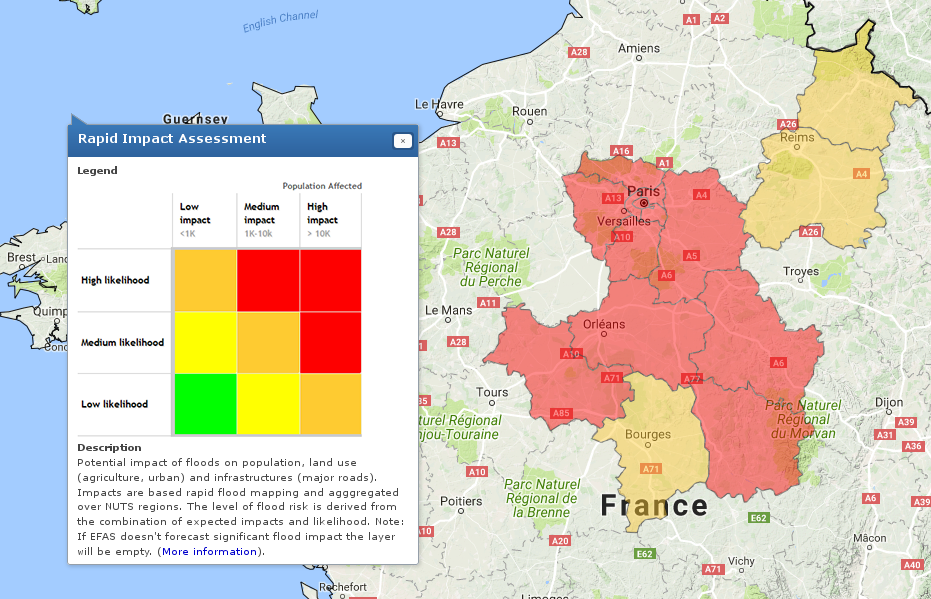
3) Impact assessment. Event-based hazard maps are combined with exposure information to assess several categories of impacts, aggregated at regional scale (shown in the “Rapid Impact Assessment” layer). Affected population, roads and cities are computed using related maps at European scale (see Dottori et al., 2016 for a complete list). The extension of urban and agricultural areas affected is computed using the Corine Land Cover. Direct economic losses are computed combining the Corine map with flood hazard variables (flood extent and depths) and a set of damage functions derived for European countries.
References
Dottori F., Salamon P., Kalas M., Bianchi A., Alfieri L., Feyen L., 2016. Benchmarking an operational procedure for rapid risk assessment in Europe. Under review in Natural Hazards Earth System Sciences Discussions, doi:10.5194/nhess-2016-338.
Alfieri, L., Salamon, P., Bianchi, A., Neal, J., Bates, P.D., Feyen, L., 2014. Advances in pan-European flood hazard mapping, Hydrological Processes, 28 (18), 4928-4937, doi:10.1002/hyp.9947.
Jongman, B., Hochrainer-Stigler, S., Feyen, L., Aerts, J.C.J.H., Mechler, R., Botzen, W.J.W., Bouwer, L.M., Pflug, G., Rojas, R., Ward, P.J., 2014. Increasing stress on disaster-risk finance due to large floods. Nature Climate Change 4, 264–268.
